Flood Risk Assessment in The London Borough of Croydon
The purpose of this page is to bring together a great deal of the information available regarding flooding in and around the Croydon area. The page includes emergency flood contact numbers, historic data and the various organisations and government bodies that are available to help flood victims and more.
If you would like any details about drainage or flood risk assessment for development or insurance purposes then please get in touch with the UNDA team today.
Croydon
The London Borough of Croydon is located within Greater London, and is one of the largest London Boroughs. It is bounded to the north by London Boroughs of Merton and Lambeth, to the east by London Borough of Bromley, to the west by London Borough of Sutton and to the south by Surrey.
The London Borough of Croydon covers an area of 87km2. The River Wandle, which drains a 200km2 catchment covering large parts of South London and the North Downs, passes through the borough. One of the sources of the Wandle, the Caterham Borne, rises in the south of the borough and flows north-west towards Purley. The Bourne only runs when groundwater levels are very high. The River Graveney, a tributary of the River Wandle, rises in the north-west corner of the borough at Thorton Heath. Some parts of the borough drain to the River Ravensbourne catchment. Its tributaries, such as thae Chaffinch Brook and St James Stream, are located in the north-east corner of the borough in Ashburton and Monks Orchard. Both the Wandle and Ravensbourne systems ultimately drain into the River Thames.
There are approximately 5,800 properties at risk of flooding from rivers within the borough, with this risk largely confined to the corridors of the Rivers Wandle and Graveney.
UNDA has years of experience producing Flood Risk Assessments and Drainage Reports in the Croydon area and across London. If you would like to disuss your planning application, development plans or existing concerns about flooding then contact our friendly team today. You can fill out the form on this page or call us now on 01293 214444
Historical Flooding in the London Borough of Croydon
Only minor flooding from rivers has occurred in Croydon since 1968, when a small area along the north-eastern boundary of the borough was affected by flooding from the River Ravensbourne. Flooding occurred from the Caterham Bourne in 2003 and to a lesser extent in 2007, with a number of properties on the edge of the A22 affected by flooding.
Caterham Bourne:
December 2013 to January 2014 was the wettest two-month period on record in the South London area. The prolonged heavy rainfall caused groundwater to rise to exceptionally high levels which led to significant flooding in the London Borough of Croydon in the areas of Kenley and Purley around the route of the Caterham Bourne. Within the Borough, flooding was particularly experienced at locations along the A22 and surrounding areas with residential properties affected at Bourne Park Close, Brighton Road, Dale Road, Foxley Hill Road, Godstone Road, Lansdown Road and Purley Park Road. The scale of the flooding was declared a Major Incident by Croydon Council (CC) on 6th February 2014 and a significant pumping operation was implemented in an effort to protect homes, businesses and critical infrastructure. For more information Croydon Flood Investigations (January – March 2014) Caterham Bourne Flood Investigation, Final: October 2014.

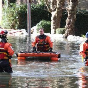
Picture: Firefighters in Dale Road, Purley during flooding associated with the Caterham Bourne, February 2014 (source: Croydonguardian.co.uk)
Merstham Bourne:
The Merstham Bourne (also sometimes referred to as the Coulsdon Bourne) is an ephemeral watercourse situated in the south of the London Borough of Croydon. During February and March 2014, flooding associated with the Merstham Bourne was experienced in South Coulsdon. Railway infrastructure around South Coulsdon Station and gardens at a number of residential properties in Reddown Road, which back on to the London to Brighton main line railway, were flooded for several weeks. Flood risk in this location is associated with the permeable underlying geology through which groundwater can easily rise and cause the Bourne and other local springs to flow, in addition to the condition of ditches and culverts, through which the water must flow. The Bourne is not designated by the Environment Agency as a Main River and is therefore classed as an ordinary watercourse. For more information Croydon Flood Investigations Jan – March 2014, Merstham Bourne Flood Investigation: Final report February 2015. https://www.croydon.gov.uk/sites/default/files/articles/downloads/Merstham%20Bourne%20S19%20Flood%20Investigation%20Report%20%E2%80%93%20February%202015.pdf
Flood Alerts
The Environment Agency provides a free Flood Warning Service for many areas at risk of flooding from rivers and the sea, which is run by the newly formed Flood Information Service. The aim of the service is to enable timely actions by residents or occupants to allow evacuation to take place unaided in the event of an impending river flood.
There are 3 flood warning areas in the Croydon Borough.
- River Wandle at Beddington Park
- Norbury Brook at Thornton Heath and Streatham Vale
- Chaffinch Brook and St James Stream at Elmers End and Upper Elmers End.
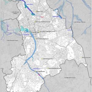
Flood Warning Areas in Croydon
To establish whether your property is located within a flood warning or alert area and to sign up to the Flood Information Service, details can be found at Environment Agency Maps and Info.
Emergency Rest Centres
During times of flooding, Croydon Borough has 10 emergency rest centres. These are located within the urban areas of include:
- Sanderstead Methodist Church, Limpsfield Road, South Croydon, Croydon, CR2 9DA
- South Croydon United Church Hall, Heathfield Road, Croydon, CR0 1ES
- United Reformed Church, Sanderstead Hill, South Croydon, Croydon, CR2 0HB
- Kenley Memorial Hall, 92 Godstone Road, Kenley, Croydon, CR8 5AB
- The Salvation Army, Booth Road, Croydon, CR0 1XY
- Salvation Army Hall, Hares Bank, Croydon, CR0 0ET
- 66 High Street, Thornton Heath, Croydon, CR7 8LF
- The Salvation Army, Westow Street, Upper Norwood, London, Croydon, SE19 3AF
- East Croydon United Reform Church, Addiscombe Grove, Croydon, CR0 5LP
- 89 Whitehorse Road, Croydon, CR0 2JJ

Map of the Emergency Rest Centre’s across the Boroughs
How to identify if you are in a potential groundwater flood area in Croydon.
The BGS Susceptibility to Groundwater Flooding map can be used to identify areas where geological conditions could enable groundwater flooding to occur and where groundwater may come close to the ground surface.
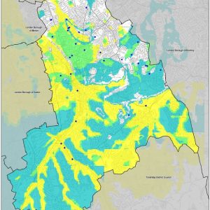
The Borough of Croydon is divided into two distinct areas with respect to bedrock geology. The north of the Borough is underlain by impermeable London Clay, whereas the south is underlain by permeable chalk. River terrace deposits are present along the river corridors throughout the Borough. The Susceptibility to Groundwater Flooding map indicates that there is potential for groundwater flooding to occur at the surface along the route of the watercourses where the permeable river terrace deposits are present and are providing potential pathways for water during periods of elevated groundwater levels in the chalk aquifer.
The Croydon Council have 37 records of groundwater flooding, with some regular hotspots in the north of the Borough.

Map of BGS Susceptibility to groundwater Flooding in Croydon – London Boroughs of Croydon, Merton, Sutton and Wandsworth Level 1 Strategic Flood Risk Assessment.
Groundwater Flooding Alerts
In some parts of England the Environment Agency are able to provide warnings when flooding from groundwater is possible. However for the Croydon Borough, if you are located within an area at risk of groundwater flooding, Shoothill GaugeMap is an interactive map and alert service with live groundwater levels which are available free of charge. Further details can be found at www.gaugemap.co.uk.
Emergency contact numbers
- LB Croydon switchboard – 020 8726 6000
- Emergency Services (Police, Fire Brigade, Ambulance) – 999
- Environment Agency Floodline – 0345 988 1188
- Power cuts and electricity problems (new national number) – 105
- Sutton & East Surrey Water 24hr Emergency Line – 01737 772000 (Is the water pipe your responsibility?)
- Thames Water Leakline – 0800 714 614
- Thames Water Sewerage – 0845 9200 888
- Thames Water Sewer Flooding 0845 9200 800
- UK Power Networks (emergencies and power cuts) – 0800 316 3105
- National Grid (Gas emergency) – 0800 111 999
- Highways maintenance – 020 8726 6000 –
Emergency email address
Where to get information
In major emergency situations, it may be necessary for the Council to issue warnings and advice to the public.
These messages will normally be broadcast on:
- radio
- television
In some cases dedicated telephone information lines may be set up.
Other methods may also be used, depending upon the nature of the emergency, including:
- Council Twitter: croydon.gov.uk/yourcroydon
- Your Croydon www.croydon.gov.uk
- loudspeaker announcements
- hand-delivered leaflets.
Personal flood plan
If you are located within a flood risk area it is recommended you produce a personal flood plan. The personal flood plan includes a list of things you should do (like moving sentimental items to safety), and provides space for you to note down important contact details such as your utility companies and insurance. Details on how to create a personal flood plan can be found at: https://www.gov.uk/government/publications/personal-flood-plan
Managing Flood Risks in Croydon
Croydon Council are responsible for managing local flood risks from surface water, groundwater and ordinary watercourses. The Environment Agency maintains a national overview and lead on flood risk from main rivers, coasts and reservoirs.
Following the severe 2008 flooding in Purley, Croydon Council with assistance from the Environment Agency pulled together a local community flood plan to help provide guidelines to those at risk in the area. https://www.croydon.gov.uk/sites/default/files/articles/downloads/purleyflood-plan.pdf
Development Planning in Croydon – Flood Risk Assessment
National, Regional and Local Policy
The Council will consider any planning application in the context of the policies contained within National, Regional and Local policy documents. These are the National Planning Policy Framework (NPPF), The London Plan (2011), The Croydon Local Plan Strategic Policies (CLP1) adopted April 2013 and the Saved Policies of the Croydon Replacement Unitary Development Plan 2006 (The Croydon Plan).
If you need a Flood Risk Assessment for a planning application then speak to our team today.
The National Planning Policy Framework can be viewed on the Department for Communities and Local Government website www.gov.uk, and the London Plan can be viewed on the Greater London Authority website www.london.gov.uk. The detailed wording of all local policies can be found on the Council’s website www.croydon.gov.uk. These documents and associated guidance set out the framework for all developments within the Borough.
Croydon Regeneration Framework
Croydon Local Plan: Strategic
The Croydon Local Plan: Strategic Policies was adopted by the council in April 2013 and is the most important planning policy document for the borough and provides an exciting and deliverable vision for Croydon up to 2031. – https://www.croydon.gov.uk/sites/default/files/articles/downloads/localplan-adopted.pdf
The Croydon Local Plan: Strategic Policies is accompanied by a number of other documents which together form the development plan for Croydon and supporting documents.
| Scale | Document |
| Croydon – strategic policy | The London Plan
Croydon Local Plan: Strategic Policies Development Plan Document (DPD)
|
| Croydon – place making | Croydon Local Plan: Detailed Policies and Proposals Development Plan Document (DPD) Policies Map
South London Waste Plan Neighbourhood Plans
|
| Croydon – development management | Supplementary Planning Documents (including the Croydon Opportunity Area Planning Framework)
Neighbourhood Development Orders Interim Planning Guidance (including Masterplans) |
The current Croydon Local Plan sets out the current development policies for the Borough and includes the following policies relevant to flood risk:
Call For Your Free Quote Now

If you need a quote or to discuss your requirements in more detail contact Jackie Stone, one of our experienced Flood Risk Consultants.
Call 01293 214444
Or Fill Out The Form Below
Croydon Local Plan Strategic – Policy SP6.4
SP6.4 The Council, as a Lead Local Flood Authority, will work in partnership with the Environment Agency, community groups, water and highways infrastructure providers, developers and other Lead Local Flood Authorities to reduce flood risk, protect groundwater and aquifers, and minimise the impact of all forms of flooding in the borough. This will be achieved by:
- Requiring major developments in Flood Zone 1 and all new development within Flood Zones 2 and 3 to provide site specific Flood Risk Assessments proportionate with the degree of flood risk posed to and by the development, taking account of the advice and recommendations within the Council’s Strategic Flood Risk Assessment and Surface Water Management Plan;
- Requiring all development, including refurbishment and conversions, to utilise sustainable drainage systems (SUDs) to reduce surface water run off and provide water treatment on site; and
- Requiring development proposals to account for possible groundwater contamination in Source Protection Zones 1 and 2.
Croydon Local Plan Strategic – Policy SP6.5
SP6.5 The Council and its partners will promote the implementation of ‘Urban Blue Corridors’, enabling a network of multifunctional spaces and corridors that provide safe routes and storage for flood water within the urban environment. This will be achieved by:
- Supporting schemes that make space for water in flood events;
- Supporting schemes to de-culvert sections of the River Wandle, Norbury Brook and Caterham Bourne;
- Preserving and enhancing landscape, heritage and culture through protection and access improvements to the borough’s ponds, open water and water heritage sites; and
- Maximising opportunities to establish overland flow paths, surface water ponding areas, urban watercourse buffer areas and multi-use flood storage areas in locations of high surface water flood risk and critical drainage areas.
Developing Urban Blue Corridors

URS/Scott Wilson, Kingston University and London Borough of Croydon were commissioned by the Department for Environment, Food and Rural Affairs (Defra) under the joint Defra/Environment Agency Strategy and Policy Development theme, to undertake a Scoping Study to highlight the current gaps in the delivery of Urban Blue Corridors and to begin to quantify their benefits, whilst providing an over-arching framework for ‘developing Urban Blue Corridors’. A Scoping Report has been produced which reports the findings of the research carried out and has been overseen by a Project Steering Group made up of representatives from Defra, Department for Communities and Local Government, the Environment Agency, the London Borough of Croydon and Kingston University. – https://www.croydon.gov.uk/sites/default/files/articles/downloads/urbanbluecorridors.pdf
Strategic Flood Risk Assessment
The strategic flood risk assessment (SFRA) process provides information on flood risk. Croydon has undertaken a joint SFRA with the boroughs of Merton, Sutton and Wandsworth.
The Level 1 SFRA assesses the flood risk in the borough and provides the information to enable each borough to apply the sequential test. https://www.croydon.gov.uk/sites/default/files/articles/downloads/Level1SFRA.pdf
The Level 2 SFRA provides the necessary information to justify the development of sites through satisfaction of the exception test and will provide information on the suitability of SuDS.
Surface Water Management Plan (SWMP)
This SWMP study has been undertaken as part of the Drain London in consultation with key local partners who are responsible for surface water management and drainage in the London area. These include the Greater London Authority, Thames Water, the Environment Agency and Transport for London. The Partners have worked together to understand the causes and effects of surface water flooding so that they can agree the most cost effective way of managing surface water flood risk for the long term.
London Borough of Croydon has historically suffered significant surface water flooding. During the flood event of summer 2007 intense rainfall exceeded the capacity of the existing highways drainage systems, and led to substantial overland flow and ponding of surface water in low lying areas. Approximately 320 properties and 26 schools reported surface water flooding to the Council during the July 2007 floods. Drainage systems were overwhelmed in several locations across the Borough in 2007, 2008, 2009 and 2010 most notably in Purley Cross, the Brighton Road and Norbury.
The chief mechanisms for flooding can be broadly divided into two categories;
Scattered Flooding Incidents – geographically dispersed and relatively isolated flooding of individual properties or small groups of properties (e.g. Chipstead Valley Road, Woodside, South Norwood);
More Severe Pluvial Flooding – more significant pluvial flooding with interlinked sources of flooding, multiple asset owners and typically affecting a significantly greater number of properties (e.g., Brighton Road, Purley Cross and South and Central Croydon).
Within the London Borough of Croydon, sixteen (16) Critical Drainage Areas (CDAs) have been identified. The Environment Agency refers to a Critical Drainage Area (CDA) as an area within Flood Zone 1 which has ‘critical drainage issues’. However, within the Croydon Surface Water Management Plan CDAs are delineated based on the following ‘working definition’: ‘a discrete geographic area (usually within an urban setting) where there may be multiple and interlinked sources of flood risk and where severe weather is known to cause flooding of the area thereby affecting people, property or local infrastructure’. Therefore the CDAs for the Croydon Borough is not restricted to just Flood Zone 1. The CDAs are used by Croydon Council in the management of local flood risk and the consideration and prioritisation of potential flood mitigation and management options within the Borough.
London Plan
The London Borough of Croydon expects all new developments to meet the drainage requirements of the London Plan 2016, policy 5.13 and its supporting document; Sustainable Design and Construction Supplementary Planning Guidance (2014) as detailed below:
Development should utilise sustainable urban drainage systems (SUDS) unless there are practical reasons for not doing so, and should aim to achieve greenfield run-off rates and ensure that surface water run-off is managed as close to its source as possible in line with the following drainage hierarchy:
- store rainwater for later use
- use infiltration techniques, such as porous surfaces in non-clay areas
- attenuate rainwater in ponds or open water features for gradual release
- attenuate rainwater by storing in tanks or sealed water features for gradual release
- discharge rainwater direct to a watercourse
- discharge rainwater to a surface water sewer/drain
- discharge rainwater to the combined sewer.
The Sustainable Design and Construction Supplementary Planning Guidance (2014) supports that developers will be expected to clearly demonstrate how all opportunities to minimise final site runoff, as close to greenfield rate as practical, have been taken. The minimum expectation for development proposals is to achieve at least 50% attenuation of the site’s (prior to re-development) surface water runoff at peak times.
Flood Risk Assessment’s for Planning in Croydon
The site specific Flood Risk Assessments should be proportionate with the degree of flood risk posed to and by the development, taking account of the advice and recommendations within the Council’s Strategic Flood Risk Assessment and Surface Water Management Plan’.
All Major Planning Applications must include a submission entitled Drainage Strategy or Flood Risk Assessment with Drainage Strategy in order to be validated. Speak to us today to organise reports for your planning application.
The FRA should meet the requirements of a site-specific FRA as outlined in paragraph 030 and 031 of the Planning Practice Guidance. Applicants should ensure they have consulted all available flood risk information including the Croydon Strategic Flood Risk Assessment, Surface Water Management Plan, Local Flood Risk Management Strategy and any local Flood Investigation Reports.
In terms of a full planning application the following should be submitted as a minimum;
- Detailed site layout at an identified scale;
- Topographical survey of the site, with contours with a demonstrated understanding of how surface water would flow across the site;
- Calculations of; change in impermeable areas between the current site and proposed site existing and proposed runoff rates and volumes during 1 in 1 year, 1 in 30 year, 1 in 100 year and 1 in 100 year + 40% climate change allowance storm events; and water storage capacity of the proposed drainage features including long term storage.
With demonstration that they meet the requirements of the policy;
- Demonstration that the proposed form of drainage has regard to the drainage hierarchy in the London Plan Policy 5.13 and industry best practice with robust evidence to support proposals where SuDS are deemed inappropriate. A statement on the benefits this brings in terms of water quality, environmental and social benefits should be provided;
- Demonstration that the proposals aim to meet greenfield runoff rate in line with London Plan Policy 5.13. Where greenfield runoff rates cannot be achieved, detailed justification of why will be required;
- Layout Plans, drawings and specification of SuDS proposed;
- Demonstration of how exceedance flows will be managed and mitigated;
- Where infiltration SuDS are proposed, they should be supported by infiltration testing in accordance with BRE365. Where infiltration testing is not possible at the full planning stage, a desktop study should be undertaken to consider the potential for infiltration SuDS at the site.
- Details of any offsite works required, together with necessary consents (where relevant) – we expect developers to have consulted with Thames Water and provide evidence of agreed points of connection and acceptable discharge rates; and,
- A site specific maintenance and ownership Plan for proposed SuDS – including details of the management and maintenance for all SuDS and how they will be secured for the lifetime of the development. An example of an appropriate management plan can be found on Susdrain – Useful frameworks and checklists.
Contacts
Spatial Planning – Development and Environment – Telephone: 020 8407 1385 – Email:
spatialplanning@croydon.gov.uk
Get In Touch
The UNDA team are able to help, advise and provide detailed Flood Risk Assessments for planning and more. Get In Touch today to find out more.